Record a route with the screen off
Start a user-visible recording, lock your phone, and keep a clean track for walks, hikes, rides, runs, commutes and drives.
Private GPS logger · Google Timeline alternative
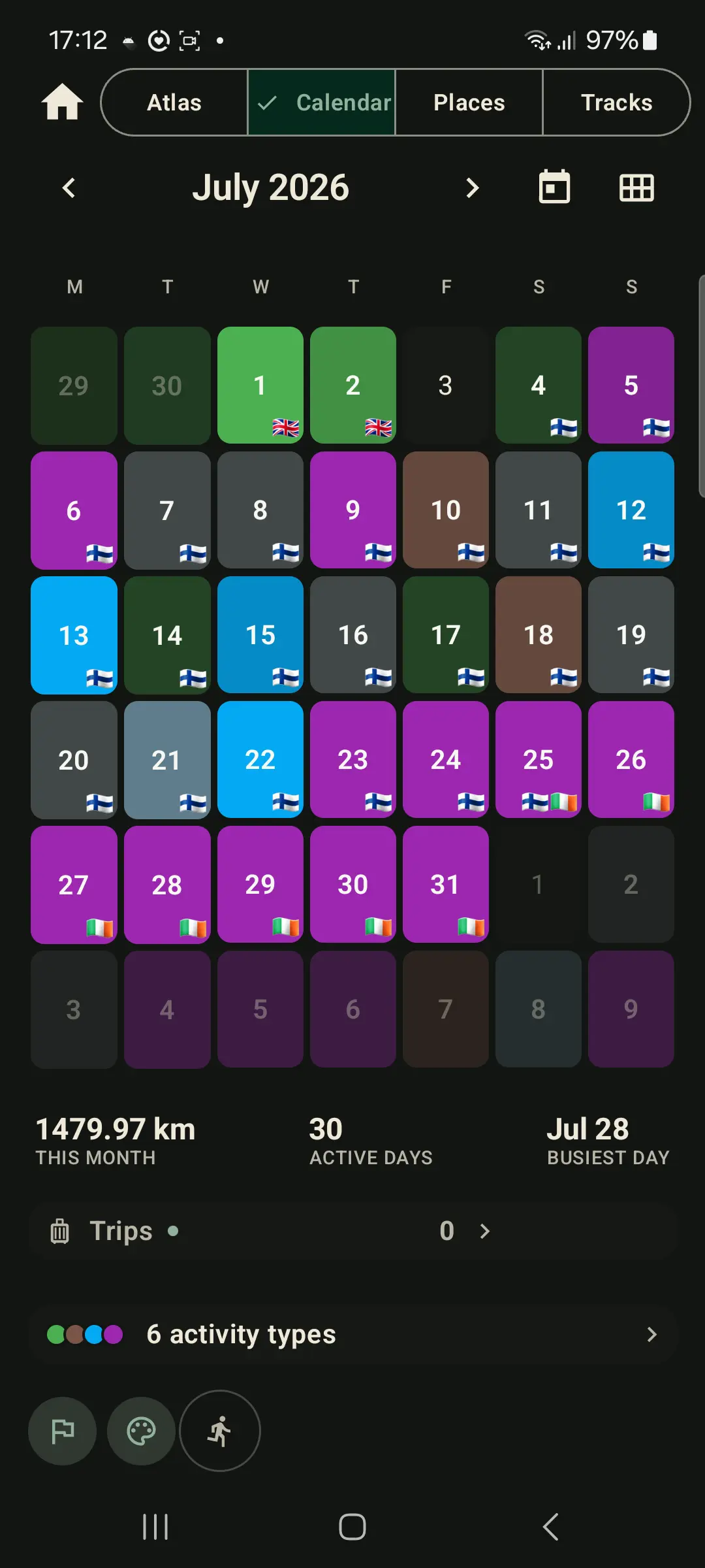
Record walks, hikes, rides and road trips with the screen off. Tap any tracked day to relive stops, movements and moments on a private timeline, then export GPX/KML whenever you need your files.

Day Story
Tap record before a walk, hike, ride, run, drive or field visit.
Tap a tracked day for a timeline of stops, movements and moments.
GPX & KML per track, plus an all-history ZIP backup. Always portable.
Optional live sharing relays your current position, not a cloud route trail.
Why people use GPS Logger
Use GPS Logger when Google Timeline is no longer enough, when another app keeps GPX behind a wall, or when you need screen-off route recording for a hike, commute, road trip or field visit without creating a social fitness profile. The trips you keep also open as a globe you can spin, from the map's layers menu, and it works with no connection.


What people install it for
Start a user-visible recording, lock your phone, and keep a clean track for walks, hikes, rides, runs, commutes and drives.
Turn saved tracks into a private day-by-day history: maps, stops, movements, the photos from that day, repeated places, countries and per-track stats.
Import old GPX tracks, export GPX/KML whenever needed, and keep a full-history ZIP backup outside the app.
Send a resettable code when someone needs to follow your live position. Stop sharing and the live session is removed.
Save OpenStreetMap, OSM Topo or OSM Cycle areas on the Recording screen so the map still works with no coverage — and without paying for data abroad.
Use route logs for road trips, field visits, mapping checks, outdoor notes, or simply remembering where you have been.
Use open files and local-first storage so your history remains useful even if you later change tools.
See it in motion

How it works

Tap once and go. It tracks in your pocket while you live your day.
Tap a day to see the route, stops, movements and notes that made it up.
Send a live dot with a resettable code and a follower limit you set.
Feature set
Your journeys, with the photos that bring them back. On a saved track, the Photos tab places each picture along the route by the time you took it, even when the photo has no GPS. Choose photos, or search a folder you pick. They stay in your gallery.
Open Globe from the map's layers menu and turn one trip, or the atlas on your History map. It works with no connection. When the phone keeps a signal, a flight is the route you flew, not a guessed curve from city to city. A long quiet stretch is only a smooth join between the positions it did record. Show just the flights, or leave them off.
Start a recording for any walk, hike, ride, drive, run or trip. It keeps tracking in the background and saves your route, distance, duration and speed when you stop.
Before a hike or while roaming, download OpenStreetMap, OSM Topo or OSM Cycle on the Recording screen. Free includes one sample tile; Pro saves full areas and neighbouring patches.
Tap a calendar day to see a map plus a chronological story of walks, rides, stops and moments, including the photos taken that day. It is built live from saved tracks; it does not edit your files.
A lifetime map of everywhere you've been, a calendar of tracked days, the places you keep returning to, and countries you have crossed.
Share your current position with a resettable code and a follower limit you set (1–20). Only your current position is stored, and it's removed after you stop.
Export individual tracks as GPX or KML, or back up your whole history as a GPX ZIP. Open formats, your data, anytime.
Motion-adaptive tracking reduces GPS frequency when you're still. A foreground notification shows while recording, with optional auto-start after a reboot.
Real app screens




GPS logging guides
Timeline
Build a day-by-day route timeline you start, stop, export and keep on your own phone.
Tutorial
Step-by-step route recording, background tracking, GPX export and whole-history backup.
Screen off
Background location, foreground notifications and battery settings for reliable route logs.
Privacy
What stays on your phone, when live sharing sends data, and how to keep a private journey map.
Offline OpenStreetMap
Save OSM, Topo or Cycle areas before a hike or while roaming. Free can try a sample tile; Pro downloads full areas.
Track detail
Restyle a route, read its climb, see the photos along it, spin it on a globe, and split or crop it.
Elevation
Why phone altitude is noisy, what terrain height fixes, what it flattens, and which to trust.
Comparison
Choose between a private route journal, a training network, or both.
Import & migrate
Bring old routes into one atlas from loose GPX files or ZIP backups.
Workflow
Export portable tracks for mapping, GIS, trip archives and route analysis.
GPS Logger runs as a foreground service so recording continues when the screen is off or you switch apps, with a persistent notification while it tracks. Motion-adaptive sampling keeps battery use low, and optional auto-start can resume recording after a reboot.
No account is required to record. Routes stay on your phone. Export makes a file there — a track as GPX or KML, or a backup ZIP — which you keep or pass on yourself. You can delete a track whenever you like. Live sharing is separate and sends only your current position while it is on. Map display and diagnostics use service providers described in the privacy policy.
FAQ
Yes. GPS Logger runs a foreground location service while recording, so tracking can continue with the screen off or while another app is open. For very long sessions, follow the in-app battery guidance so Android does not suspend it.
It replaces the route-memory parts for people who want user-started recordings, daily timelines, local-first storage and exportable GPX/KML files. It is not a silent always-on copy of every movement.
No. Recording starts only when you start it, and stops when you stop. The one exception is optional auto-start after a reboot, which you enable yourself.
On your device. Export makes a file on the phone: one track as GPX or KML, or your history as a backup ZIP. You keep that file, or you hand it to someone yourself. The file is never sent to a server. Live sharing is separate, and it sends only your current position while you leave it on.
You share a resettable code and pick a follower limit (1–20). Anyone with the code sees only your current position on a live map. The position is removed when you stop, and unattended positions auto-delete within 7 days.
Yes. Export any track as GPX or KML, or back up your entire history as a GPX ZIP. There's no lock-in.
Yes. You can import GPX files and Google Timeline exports you choose, including ZIP backups — unlimited on every plan. The free version shows your 10 most recent trips in the app; Pro shows all of them.
Yes. Install the app and record real routes first. If you later need more capacity, the app explains the available options in context.
Free includes GPS recording, photos on the trips you can open (no separate photo limit), the atlas, calendar and places from that visible history, and the latest 10 tracks. Opening one trip on the globe is free. Free can spin the whole history on the atlas globe three times, then the same latest 10 trips; Pro keeps the whole history there. You also get full stored-resolution single-track export, an all-history backup, unlimited splitting and cropping, unlimited Google Timeline and GPX import, 15 minutes a day each way of live sharing, and OpenStreetMap, OSM Topo and OSM Cycle whenever the phone has a connection. Saving maps for offline use is one sample area on Free and full areas on Pro.
Yes, on the Recording screen: switch to OpenStreetMap, OSM Topo or OSM Cycle and tap Download this area. Free includes one sample tile to try with radios off; Pro downloads full areas and neighbouring patches. This is not a worldwide Google Maps offline pack.
Start with one walk, ride or drive. Export it as GPX, keep it in your atlas, or simply let your private route history grow over time.

Free to start · No ads · Privacy-first