
Elevation sources
GPS elevation on Android: recorded altitude or terrain data?
This guide came from a real saved route where the climb total looked far less trustworthy than the route itself. The usual advice is to “correct” the elevation against terrain data — but that quietly assumes terrain height is the true answer, and for a bridge, a tunnel or a ski lift it is not. The honest question is which of the two heights describes your trip. GPS Logger answers it by letting you switch the view between them, on one track, without rewriting anything.
Why GPS elevation goes wrong
Phone GPS is usually much better horizontally than vertically. Latitude and longitude may be good enough to draw your path, while altitude jumps up and down because satellite geometry, tree cover, buildings, weather and phone sensors all add noise. Barometers help on some phones, but pressure changes can make a route drift upwards over an afternoon even when you stayed at the same height.
That noise matters because elevation gain is cumulative. Small false climbs, repeated over thousands of points, turn a flat commute into a mountain stage. A good tracker has to smooth the profile and ignore movement below the noise floor before it adds anything to the total — GPS Logger does, which is why its gain figure is usually lower and steadier than a raw sum of the ups.
Two different heights, not a right one and a wrong one
Recorded altitude is the height that came with the track: from your phone’s barometer or GPS, or from the watch or device that recorded a file you imported. It knows you were on a bridge, in a tunnel, on the fourth floor or in a plane — and it drifts with the weather.
Terrain elevation is the height of the ground itself at each coordinate, read from a global elevation model. It is weather-proof and repeats exactly on the same route, so two recordings of your usual loop finally agree with each other. In exchange it flattens everything above or below ground: a bridge over a valley reads as the valley floor.
Which one should you trust?
Pick whichever matches the trip you actually made.
Terrain usually reads better when
- The recorded profile has impossible spikes or sudden drops.
- A flat walk or commute reports far too much climbing.
- Several recordings of the same route disagree about the elevation gain.
- An imported GPX file has missing, flat or clearly poor altitude values.
- You are walking, hiking, trail running, cycling or driving along the ground.
Recorded altitude is the better answer when
- The route crosses bridges, flyovers or viaducts.
- It runs through tunnels, underpasses or below ground.
- You were on a ski lift, cable car, ferry or aircraft.
- The trip climbed inside a building, tower or multi-storey car park.
- Your phone has a barometer, the weather was stable, and the recorded curve already looks sane.
Terrain data has a resolution, too
Terrain elevation is steadier than a barometer, but that is not the same as being more accurate. It is read from a global model on a fixed grid: in GPS Logger each sample covers roughly twelve metres of ground at Irish latitudes, and the elevation model behind that grid is smoothed further still. Anything narrower than the grid is averaged away before you ever see it — and a mountain summit is exactly that: a cone narrower than the cell it sits in.
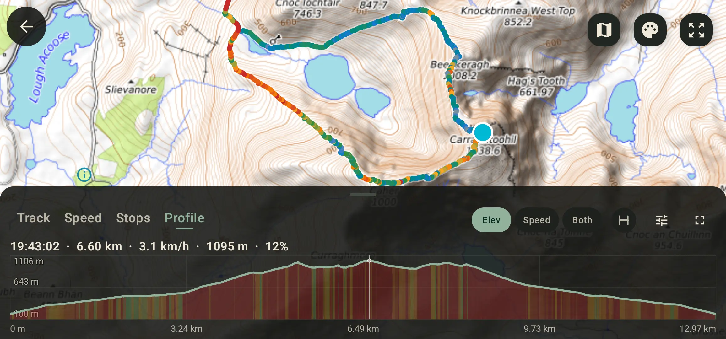
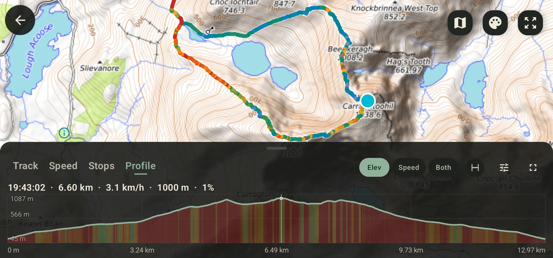
The route above runs over Carrauntoohil, Ireland’s highest point, which the map sheet gives as 1038.6 m. At the same second on the same track:
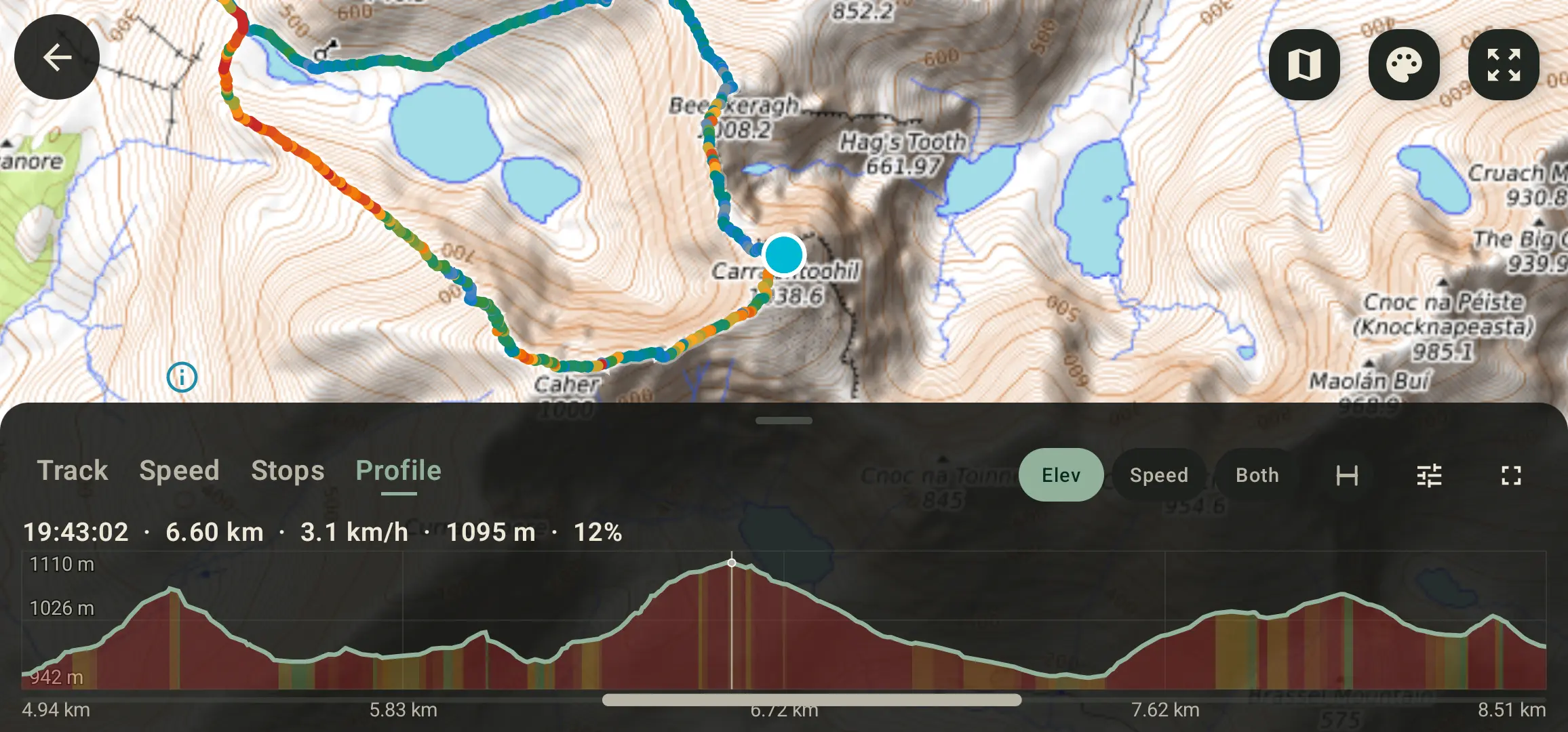
- Recorded read 1095 m — about 56 m over, the barometer sitting high that evening.
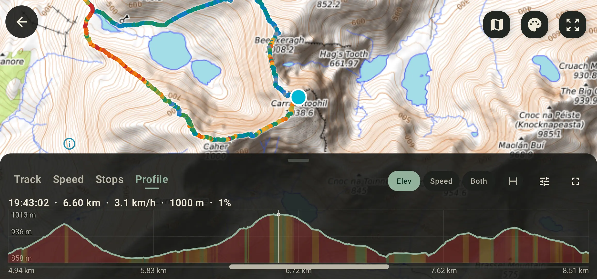
- Terrain read 1000 m — about 39 m under, the summit cone flattened by the grid.
Neither one is the mountain. That is the honest state of phone elevation data, and it is why the app offers a switch rather than a correction: terrain is the better default for a route that follows the ground, but it is not a truth to be restored, and on a sharp peak it will read low.
Nothing is overwritten
Earlier versions of GPS Logger offered a destructive elevation correction that replaced a track’s altitude with terrain values, plus a batch job to do it to a whole library at once. Both are gone. What replaced them is a per-track view switch:
- Switching to Terrain redraws the profile and recalculates the elevation gain on screen.
- The saved recording keeps its own altitude, always.
- GPX and KML exports always carry the recorded altitude, whichever view you were looking at.
- You can switch back and forth as often as you like, because there is nothing to undo.
If a track was corrected by one of those older versions, its original altitude is genuinely gone and the app says so rather than pretending there is something to switch back to.
How to switch elevation source in GPS Logger
- Record a route, or import a GPX file.
- Open the track from History.
- Open the Profile view, which draws elevation, speed, or both together.
- Open the chart options and set Elevation source to Terrain. The app needs a connection the first time, to read the ground heights along that route.
- Compare the profile shape and the elevation gain against Recorded, and leave it on whichever describes the trip.
Reading terrain elevation is free for one track per day; Pro switches any track, any time. Either way it is per track, so a route you never look at never costs a lookup.
Privacy and export notes
GPS Logger is built around local track history: your routes stay on your device unless you export them, share your live location, or use another feature that clearly sends data out. Reading terrain elevation looks up ground heights for the area a track covers, and needs no account and no GPX upload workflow.
Because the recording is never rewritten, export stays honest as well: save the route as GPX or KML and it carries the altitude your device actually recorded, ready for any other mapping tool to interpret its own way.